CHANGED TRAFFIC CONDITIONS

Cyclists of all ages and abilities are expected to participate in the Tour de Brisbane sponsored by Transurban throughout Brisbane and fundraise for The Common Good, an initiative of The Prince Charles Hospital Foundation.

To deliver a safe and secure event for riders and spectators, there will be major road closures and changed traffic conditions throughout Brisbane under the professional management of Queensland Police Service and Altus Traffic Control.

Motorists are advised to make alternate travel arrangements and give extra time to reach your destination as your normal route may experience delays or be unavailable.

On the event day, map apps such as Google, Waze, and Apple Maps will automatically calculate a detour around the road closures.

Roads will be progressively reopened throughout the event.

Should you wish to discuss your individual requirements, please do not hesitate to contact us. 

P: 07 3124 6099

E: tourdebrisbane@nxsports.org


Public Transport

There will be significant disruptions to bus services in Brisbane on Sunday 13 April 2025. More information about impacts to public transport services, will be available on the TransLink website shortly. 

Thank you for your cooperation and for supporting all of the volunteers, spectators, and the athletes who train so hard for this day. Together we can create a successful day for all.

Road Closure Flyers

This event operates under a full road closure. For diversion information, please call our office on 07 3124 6099.

Flyers have been delivered to residents in affected suburbs. For reference, these are included below. 


Zoomable Map

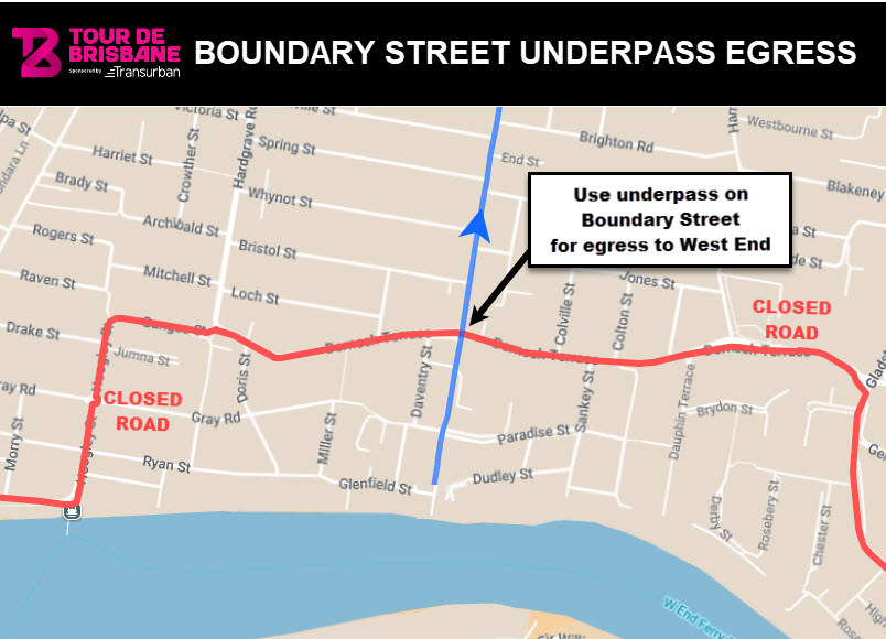
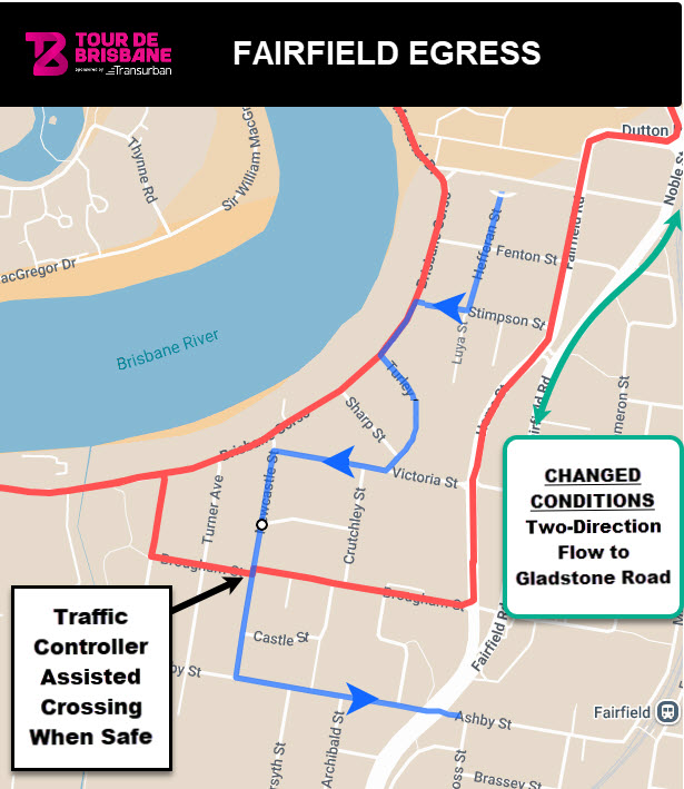
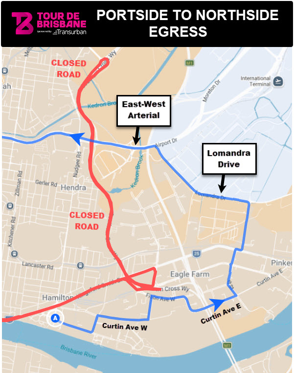
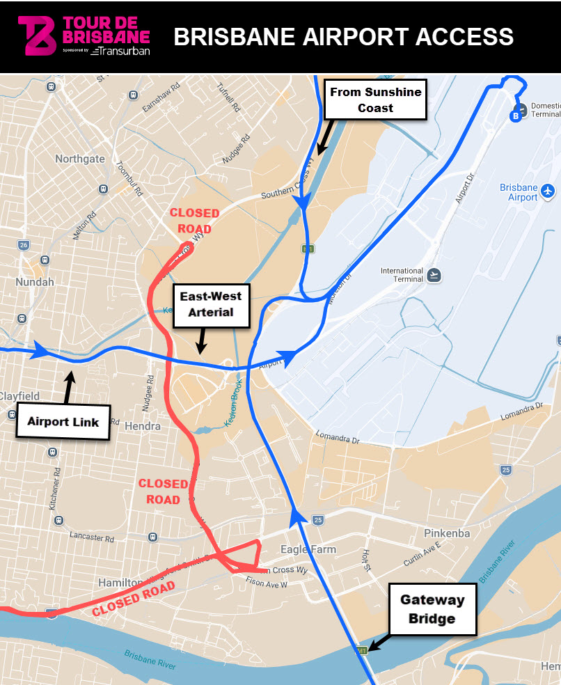
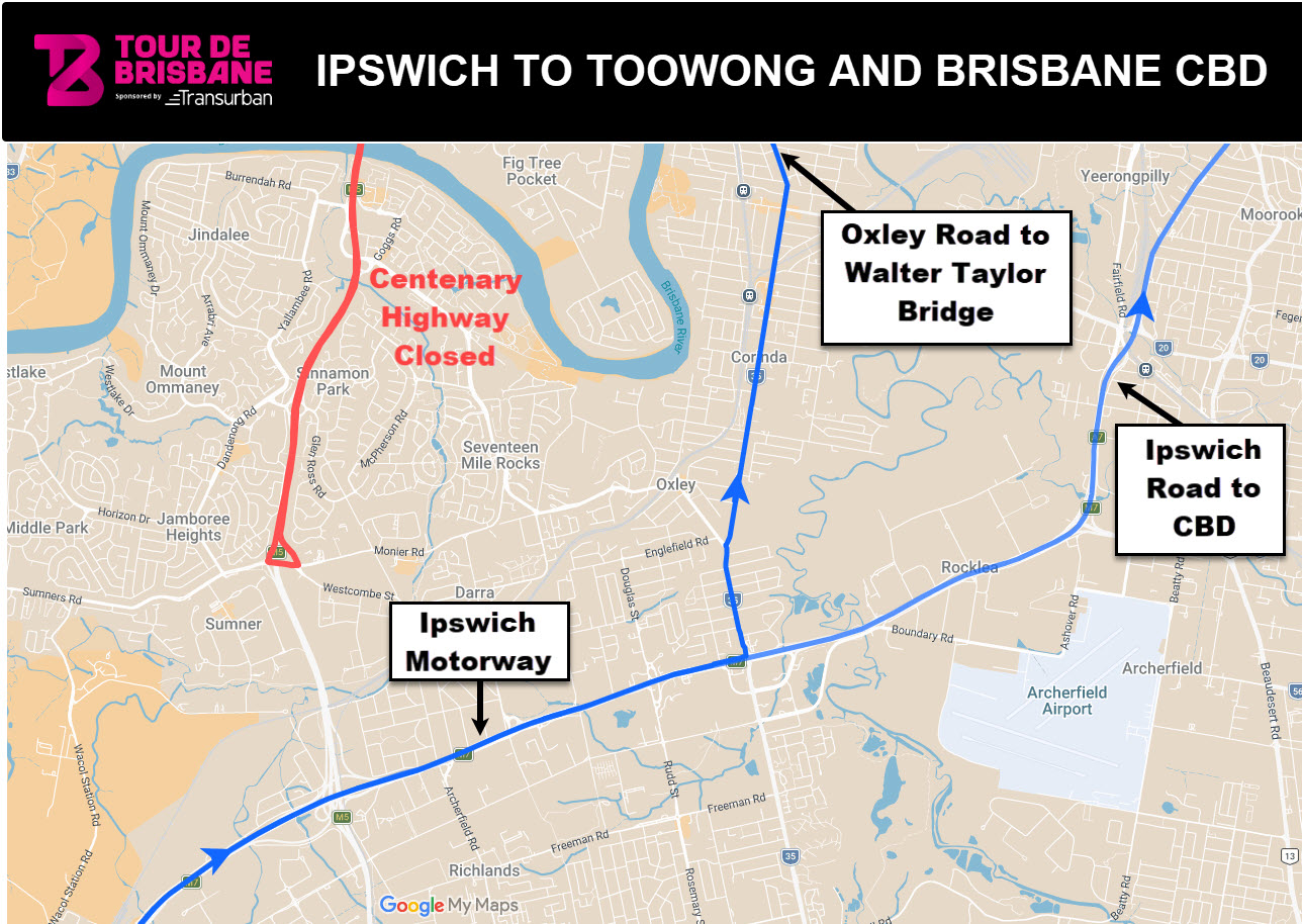
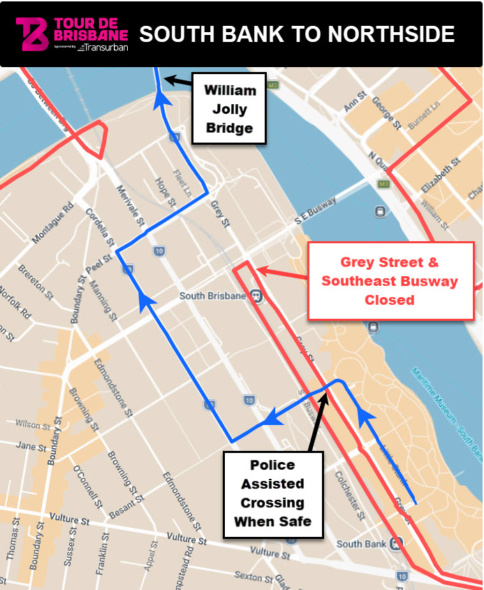
The red lines on the below map indicate closed roads.  Click the square in the top left corner to view detailed timing throughout the day as roads progressively open.

Need help using the map?

List of Road Impacts

 
SUNDAY 13 APRIL 2025
SuburbStreet/Road AlteredStatusExtra DetailsRoad ClosedRoad Open
AlbionAlbion Agnes Street Between Yulestar Street and Kingsford Smith DriveChanged ConditionsBetween Yulestar Street and Kingsford Smith Drive4:3012:30
AlbionAlbion Amy Street Between Breakfast Creek Road and Yulestar StreetChanged ConditionsBetween Breakfast Creek Road and Yulestar Street4:3012:30
AlbionAlbion Hunt Street Between Yulestar Street and Kingsford Smith DriveChanged ConditionsBetween Yulestar Street and Kingsford Smith Drive4:3012:30
AlbionAlbion Yulestar Street Between Amy Street and Hunt StreetChanged ConditionsBetween Amy Street and Hunt Street4:3012:30
Albion / HamiltonAlbion / Hamilton Kingsford Smith Drive Between Breakfast Creek Road and Schneider RoadClosed WestboundBetween Breakfast Creek Road and Schneider Road5:3012:30
Albion / NewsteadAlbion / Newstead Breakfast Creek Road Between Amy Street and Newstead AvenueChanged ConditionsBetween Amy Street and Newstead Avenue4:3012:30
Bowen HillsBowen Hills Airport Link Between Eastbound On Ramp to Inner City BypassFull Road ClosureBetween Eastbound On Ramp to Inner City Bypass4:3012:30
Bowen HillsBowen Hills Airport Link Between Westbound Off Ramp to the Inner City BypassFull Road ClosureBetween Westbound Off Ramp to the Inner City Bypass4:3012:30
Bowen HillsBowen Hills CLEM7 Offramp to ICB Both Eastbound and WestboundFull Road ClosureBoth Eastbound and Westbound4:3012:30
Bowen HillsBowen Hills ICB Eastbound Between Hale Street and Kingsford Smith DriveFull Road ClosureBetween Hale Street and Kingsford Smith Drive4:3012:30
Breakfast CreekBreakfast Creek ICB Westbound Between Kingsford Smith Drive and Hale StreetFull Road ClosureBetween Kingsford Smith Drive and Hale Street4:3012:30
Brisbane CityBrisbane City Adelaide Street Between Queen Street and Ivory StreetFull Road ClosureBetween Queen Street and Ivory Street5:008:30
Brisbane CityBrisbane City Alice Street Between William Street and Edward StreetFull Road ClosureBetween William Street and Edward Street5:008:30
Brisbane CityBrisbane City Alice Street On Ramp To Riverside ExpresswayFull Road ClosureTo Riverside Expressway5:008:30
Brisbane CityBrisbane City Eagle Street Between Market Street and Wharf StreetFull Road ClosureBetween Market Street and Wharf Street5:008:30
Brisbane CityBrisbane City Edward Street Between Mary Street and Alice StreetFull Road ClosureBetween Mary Street and Alice Street5:008:30
Brisbane CityBrisbane City Elizabeth Street Between William Street and George StreetFull Road ClosureBetween William Street and George Street5:008:30
Brisbane CityBrisbane City Elizabeth Street On Ramp and Elizabeth Street Off Ramp Off Riverside ExpresswayFull Road ClosureOff Riverside Expressway5:008:30
Brisbane CityBrisbane City Felix Street Between Margaret Street and Mary StreetFull Road ClosureBetween Margaret Street and Mary Street5:008:30
Brisbane CityBrisbane City George Street Between Margaret Street and Alice StreetFull Road ClosureBetween Margaret Street and Alice Street5:008:30
Brisbane CityBrisbane City Inner Northern Busway Between Victoria Bridge (William Street) and Herston Bus Station (Victoria Park)Full Road ClosureBetween Victoria Bridge (William Street) and Herston Bus Station (Victoria Park)5:0013:00
Brisbane CityBrisbane City Ivory Street (including Ivory Street Tunnel) Between Ann Street and Brunswick StreetFull Road ClosureBetween Ann Street and Brunswick Street5:008:30
Brisbane CityBrisbane City Margaret Street Between Edward Street and Felix StreetFull Road ClosureBetween Edward Street and Felix Street5:008:30
Brisbane CityBrisbane City Margaret Street On Ramp and Margaret Street Off Ramp Off Riverside ExpresswayFull Road ClosureOff Riverside Expressway5:008:30
Brisbane CityBrisbane City Mary Street Between Edward Street and Eagle StreetFull Road ClosureBetween Edward Street and Eagle Street5:008:30
Brisbane CityBrisbane City North Quay Between Victoria Bridge and Adelaide StreetFull Road ClosureBetween Victoria Bridge and Adelaide Street4:0013:30
Brisbane CityBrisbane City Queen Street Between Eagle Street and Adelaide StreetFull Road ClosureBetween Eagle Street and Adelaide Street5:008:30
Brisbane CityBrisbane City Victoria Bridge Downriver Cycleway Across the Bridge DeckPathway ClosureAcross the Bridge Deck4:0013:30
Brisbane CityBrisbane City Victoria Bridge Downriver Pedestrian Footpath Across the Bridge DeckPathway ClosureAcross the Bridge Deck4:0013:30
Brisbane CityBrisbane City William Street Between Victoria Bridge and Alice StreetFull Road ClosureBetween Victoria Bridge and Alice Street4:008:30
Brisbane CityBrisbane City William Street Between Victoria Bridge and Elizabeth StreetFull Road ClosureBetween Victoria Bridge and Elizabeth Street4:0013:30
Dutton ParkDutton Park Gladstone Road Between Annerley Road and Dornoch TerraceFull Road ClosureBetween Annerley Road and Dornoch Terrace5:009:00
Fortitude ValleyFortitude Valley Story Bridge Between Ann Street and Main StreetFull Road ClosureBetween Ann Street and Main Street5:008:30
HamiltonHamilton Cullen Avenue East Between Links Avenue North and Harvey Street NorthChanged ConditionsBetween Links Avenue North and Harvey Street North5:3012:30
HamiltonHamilton Fison Ave West Between Eagleview Place and Kingsford Smith DrFull Road ClosureBetween Eagleview Place and Kingsford Smith Dr5:3012:30
HamiltonHamilton Harbour Road Between Hercules Street and Kingsford Smith DriveFull Road ClosureBetween Hercules Street and Kingsford Smith Drive5:3012:30
HamiltonHamilton Links Avenue North Between Kingsford Smith Drive and Cullen Avenue EastFull Road ClosureBetween Kingsford Smith Drive and Cullen Avenue East5:3012:30
HamiltonHamilton Northshore Way Between Hercules Street and Kingsford Smith DriveFull Road ClosureBetween Hercules Street and Kingsford Smith Drive5:3012:30
HamiltonHamilton Remora Road Between Hercules Street and Kingsford Smith DriveChanged ConditionsBetween Hercules Street and Kingsford Smith Drive5:3012:30
HamiltonHamilton Theodore Street Between Cullen Avenue West and Kingsford Smith DriveChanged ConditionsBetween Cullen Avenue West and Kingsford Smith Drive5:3012:30
HendraHendra Southern Cross Way Between Gateway Bridge and Gateway Motorway (Nudgee)Closed NorthboundBetween Gateway Bridge and Gateway Motorway (Nudgee)5:3012:00
HendraHendra Southern Cross Way Between Gateway Bridge and Gateway Motorway (Nudgee)Closed SouthboundBetween Gateway Bridge and Gateway Motorway (Nudgee)5:3012:00
HerstonHerston Gilchrest Avenue Between ICB Offramp (Herston) and Victoria ParkFull Road ClosureBetween ICB Offramp (Herston) and Victoria Park4:3012:30
HerstonHerston Legacy Way Tunnel Westbound From Inner City Bypass to Western FreewayFull Road ClosureFrom Inner City Bypass to Western Freeway4:3012:30
Highgate HillHighgate Hill Dornoch Terrace Between Gladstone Road and Hardgrave RoadFull Road ClosureBetween Gladstone Road and Hardgrave Road5:009:00
IndooroopillyIndooroopilly Moggill Road, Onramp to Western Freeway Onramp, Southbound Between Moggill Road, right hand turn lane, southboundFull Road ClosureBetween Moggill Road, right hand turn lane, southbound5:0010:00
Kangaroo PointKangaroo Point Bell Street Between Main Street and River TerraceChanged ConditionsBetween Main Street and River Terrace5:008:30
Kangaroo PointKangaroo Point Ellis Street Between Leopard Street and Lower River TerraceFull Road ClosureBetween Leopard Street and Lower River Terrace5:008:30
Kangaroo PointKangaroo Point Leopard Street Between River Terrace and Vulture StreetFull Road ClosureBetween River Terrace and Vulture Street5:008:30
Kangaroo PointKangaroo Point Llewellyn Street Between Main Street and River TerraceChanged ConditionsBetween Main Street and River Terrace5:008:30
Kangaroo PointKangaroo Point Lockerbie Street Between Main Street and Leopard StreetChanged ConditionsBetween Main Street and Leopard Street5:008:30
Kangaroo PointKangaroo Point Lower River Terrace Between Ellis Street and Dock StreetFull Road ClosureBetween Ellis Street and Dock Street5:008:30
Kangaroo PointKangaroo Point Main Street Between Story Bridge and Quinton StreetFull Road ClosureBetween Story Bridge and Quinton Street5:008:30
Kangaroo PointKangaroo Point Main Street Between Vulture Street and Quinton StreetChanged ConditionsBetween Vulture Street and Quinton Street5:008:30
Kangaroo PointKangaroo Point Mark Lane Between Main Street and Leopard StreetChanged ConditionsBetween Main Street and Leopard Street5:008:30
Kangaroo PointKangaroo Point O'Connell Street Between Lambert Street and Shafston AvenueChanged ConditionsBetween Lambert Street and Shafston Avenue5:008:30
Kangaroo PointKangaroo Point Paton Street Between Main Street and River TerraceChanged ConditionsBetween Main Street and River Terrace5:008:30
Kangaroo PointKangaroo Point River Terrace Between Main Street and Leopard StreetFull Road ClosureBetween Main Street and Leopard Street5:008:30
Kangaroo PointKangaroo Point Thornton Street Between Main Street and Story BridgeFull Road ClosureBetween Main Street and Story Bridge4:308:30
Kangaroo PointKangaroo Point Walmsley Street Between Main Street and River TerraceChanged ConditionsBetween Main Street and River Terrace5:008:30
Kangaroo PointKangaroo Point Wild Street Between Leopard Street and Dead EndFull Road ClosureBetween Leopard Street and Dead End5:008:30
MiltonMilton Hale Street Northbound Between Coronation Drive to Kelvin Grove OfframpChanged ConditionsBetween Coronation Drive to Kelvin Grove Offramp4:3012:30
Milton / South BrisbaneMilton / South Brisbane Go Between Bridge Between Montague Road and Coronation DriveFull Road ClosureBetween Montague Road and Coronation Drive5:009:30
Milton / South BrisbaneMilton / South Brisbane Hale Street Southbound Between Musgrave Road and Coronation DriveFull Road ClosureBetween Musgrave Road and Coronation Drive5:009:30
Mt Coot-thaMt Coot-tha Scenic Drive Between Mt Coot-tha Road and Sir Samuel Griffith DriveFull Road ClosureBetween Mt Coot-tha Road and Sir Samuel Griffith Drive5:0011:30
NorthgateNorthgate Toombul Road Between Nudgee Road and Southern Cross WayFull Road ClosureBetween Nudgee Road and Southern Cross Way5:3012:00
Red HillRed Hill Hale Street Northbound Between Kelvin Grove Offramp to Inner City BypassFull Road ClosureBetween Kelvin Grove Offramp to Inner City Bypass4:3012:30
South BrisbaneSouth Brisbane Christie Street Between Vulture Street and Dock StreetChanged ConditionsBetween Vulture Street and Dock Street5:008:30
South BrisbaneSouth Brisbane Colchester Street Between South East of Tribune Street and Ernest StreetFull Road ClosureBetween South East of Tribune Street and Ernest Street5:008:30
South BrisbaneSouth Brisbane Dock Street Between Lower River Terrace and Vulture StreetFull Road ClosureBetween Lower River Terrace and Vulture Street5:008:30
South BrisbaneSouth Brisbane Eastern Busway Between UQ Station and Buranda StationFull Road ClosureBetween UQ Station and Buranda Station5:009:00
South BrisbaneSouth Brisbane Ernest Street Between Merivale Street and Grey StreetLocal Resident Access OnlyBetween Merivale Street and Grey Street5:009:00
South BrisbaneSouth Brisbane Glenelg Street Between Merivale Street and Grey StreetLocal Resident Access OnlyBetween Merivale Street and Grey Street5:009:00
South BrisbaneSouth Brisbane Grey Street Between Vulture Street and Peel StreetFull Road ClosureBetween Vulture Street and Peel Street5:009:00
South BrisbaneSouth Brisbane Little Dock Street Between Dock Street and Dead EndChanged ConditionsBetween Dock Street and Dead End5:008:30
South BrisbaneSouth Brisbane Little Stanley Street Between Tribune Street and Grey StreetChanged ConditionsBetween Tribune Street and Grey Street5:009:00
South BrisbaneSouth Brisbane South East Busway Between South Bank Station and 8 Mile Plains StationFull Road ClosureBetween South Bank Station and 8 Mile Plains Station5:009:00
South BrisbaneSouth Brisbane Tribune Street Between Little Stanley Street and Merivale StreetFull Road ClosureBetween Little Stanley Street and Merivale Street5:008:30
South BrisbaneSouth Brisbane Vulture Street Between Stanley Street and Grey StreetChanged ConditionsBetween Stanley Street and Grey Street5:008:30
SumnerSumner Ipswich Motorway Offramp To Centenary Highway Northbound Between Eastbound and Westbound RampsFull Road ClosureBetween Eastbound and Westbound Ramps5:0010:00
SumnerSumner Sumners Road Between Dandenong Road and Monier RoadChanged ConditionsBetween Dandenong Road and Monier Road5:0010:00
SumnerSumner Western Freeway and Centenary Highway Northbound Between Ipswich Motorway and Moggill RoadFull Road ClosureBetween Ipswich Motorway and Moggill Road5:0010:00
SumnerSumner Western Freeway and Centenary Highway Southbound Between Moggill Road and Ipswich MotorwayFull Road ClosureBetween Moggill Road and Ipswich Motorway5:0010:00
ToowongToowong Birdwood Terrace Between Mt Coot-tha Road and Stuartholme RoadLocal Resident Access OnlyBetween Mt Coot-tha Road and Stuartholme Road5:0011:30
ToowongToowong Legacy Way Tunnel Eastbound From Western Freeway to Inner City BypassFull Road ClosureFrom Western Freeway to Inner City Bypass4:3012:30
ToowongToowong Milton Road Between Miskin Street and Western FreewayFull Road ClosureBetween Miskin Street and Western Freeway5:0011:30
ToowongToowong Milton Road Between Croydon Street and Miskin StreetChanged ConditionsBetween Croydon Street and Miskin Street5:0011:30
ToowongToowong Mt Coot-tha Road Between Western Freeway and Sir Samuel Griffith DriveFull Road ClosureBetween Western Freeway and Sir Samuel Griffith Drive5:0011:30
ToowongToowong Mt Coot-tha Road Between Milton Road and Western FreewayFull Road ClosureBetween Milton Road and Western Freeway5:0011:30
ToowongToowong Mt Coot-tha Road Between Sir Samuel Griffiths Drive and Milton RoadFull Road ClosureBetween Sir Samuel Griffiths Drive and Milton Road5:0011:30
ToowongToowong Paddington Drive Between Sir Samuel Griffith Drive and Stuartholme SchoolChanged ConditionsBetween Sir Samuel Griffith Drive and Stuartholme School5:0011:30
ToowongToowong Simpsons Road Between Carwoola Street and Sir Samuel Griffiths DriveChanged ConditionsBetween Carwoola Street and Sir Samuel Griffiths Drive5:0011:30
ToowongToowong Sir Samuel Griffith Drive Between Scenic Drive and Mt Coot-tha RoadFull Road ClosureBetween Scenic Drive and Mt Coot-tha Road5:0011:30
ToowongToowong Western Freeway Northbound Between Moggill Road and Mt Coot-tha RoadFull Road ClosureBetween Moggill Road and Mt Coot-tha Road5:0011:30
ToowongToowong Western Freeway Southbound Between Mt. Coot-tha Road and Moggill RoadFull Road ClosureBetween Mt. Coot-tha Road and Moggill Road5:0011:30
West EndWest End Boundary Street Between Riverside Drive Bike Path and Montague RoadPathway ClosureBetween Riverside Drive Bike Path and Montague Road5:009:30
West EndWest End Ganges Street Between Hardgrave Road and Hoogley StreetFull Road ClosureBetween Hardgrave Road and Hoogley Street5:009:00
West EndWest End Hill End Terrace Between Montague Road and Riverside DriveFull Road ClosureBetween Montague Road and Riverside Drive5:009:00
West EndWest End Hoogley Street Between Ganges Street and Orleigh StreetFull Road ClosureBetween Ganges Street and Orleigh Street5:009:00
West EndWest End Orleigh Street Between Hoogley Street and Montague RoadFull Road ClosureBetween Hoogley Street and Montague Road5:009:00
West EndWest End Riverside Drive Between Forbes Street and Go Between BridgeFull Road ClosureBetween Forbes Street and Go Between Bridge5:009:30
West EndWest End Riverside Drive Bike Path Between Forbes Street and Go Between BridgePathway ClosureBetween Forbes Street and Go Between Bridge5:009:30

Access and Detour Maps

You can click the images below to enlarge. 


Our partners